|
Größe: 818
Kommentar: Abkürzungen
|
Größe: 2700
Kommentar: Link zur HS
|
| Gelöschter Text ist auf diese Art markiert. | Hinzugefügter Text ist auf diese Art markiert. |
| Zeile 4: | Zeile 4: |
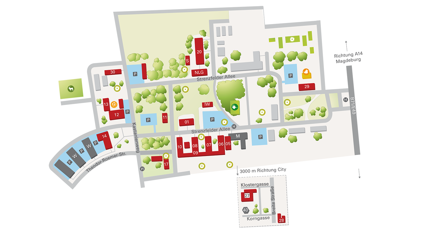
| ||01||HG||[[Hauptgebäude]]|| ||02||AP||[[Alte Post]]|| ||03||OH||[[Oberdorfhalle|Sauna]]|| ||04||OH||[[Oberdorfhalle|Sportbarracke]]|| ||05||RS||[[Ratssaal]]|| ||06||MH||[[Müntzerhaus]]|| ||07||HH||[[Helriegelhaus]]|| ||08||TH||[[Thünenhaus]]|| ||09|| ||[[Zwischenbau]]|| ||10||VG||[[Verwaltungsgebäude]]|| ||11||PH||[[Putzhaus]]|| ||12||OH||[[Oberdorfhalle]]|| ||13||OH||[[Sprachlabor]]|| ||14||RH||[[Roemerhaus]]|| ||15|| ||[[Bienenhaus]]|| ||17||HS1||[[Hörsaal 1]]|| ||20||NLG||[[Kühlhalle]]|| ||27||KL||[[Kloster]]|| ||28||AR||[[Altes Rathaus]]|| ||29||BT||[[Biotechnikum]]|| ||30||FS||[[Feldschlösschen]]|| ||M|| ||[[Mensa]]|| ||NLG||NLG||[[Neues-Labor-Gebäude]]|| ||IW||IW||[[Innovationswerkstatt]]|| ||W|| ||[[Wohnheime]]|| |
||01||HG||[[Hauptgebäude]]||https://www.openstreetmap.org/#map=19/51.823947/11.707604|| ||02||AP||[[Alte Post]]||https://www.openstreetmap.org/#map=19/51.822813/11.706592|| ||03||OH||[[Oberdorfhalle|Sauna]]||https://www.openstreetmap.org/#map=19/51.823839/11.704610|| ||04||OH||[[Oberdorfhalle|Sportbarracke]]||https://www.openstreetmap.org/#map=19/51.823839/11.704610|| ||05||RS||[[Ratssaal]]||https://www.openstreetmap.org/#map=19/51.823947/11.709470|| ||06||MH||[[Müntzerhaus]]||https://www.openstreetmap.org/#map=19/51.823622/11.709259|| ||07||HH||[[Helriegelhaus]]||https://www.openstreetmap.org/#map=19/51.823510/11.708784|| ||08||TH||[[Thünenhaus]]||https://www.openstreetmap.org/#map=19/51.823379/11.708226|| ||09|| ||[[Marxhaus]]/[[Zwischenbau]]||https://www.openstreetmap.org/#map=19/51.822827/11.707244|| ||10||VG||[[Verwaltungsgebäude]]||https://www.openstreetmap.org/#map=19/51.823314/11.707327|| ||11||PH||[[Putzhaus]]||https://www.openstreetmap.org/#map=19/51.823879/11.706598|| ||12||OH||[[Oberdorfhalle]]||https://www.openstreetmap.org/#map=19/51.823488/11.704549|| ||13||OH||[[Sprachlabor]]||https://www.openstreetmap.org/#map=19/51.823664/11.703964|| ||14||RH||[[Roemerhaus]]||https://www.openstreetmap.org/#map=19/51.822750/11.704439|| ||15|| ||[[Bienenhaus]]||https://www.openstreetmap.org/#map=18/51.826515/11.711656|| ||17||HS1||[[Hörsaal 1]]||https://www.openstreetmap.org/#map=19/51.822827/11.707244|| ||20||NLG||[[Kühlhalle]]||https://www.openstreetmap.org/#map=19/51.825797/11.707097|| ||27||KL||[[Kloster]]||https://www.openstreetmap.org/#map=19/51.800171/11.731132|| ||28||AR||[[Altes Rathaus]]||https://www.openstreetmap.org/#map=19/51.798977/11.735855|| ||29||BT||[[Biotechnikum]]||https://www.openstreetmap.org/#map=18/51.825766/11.711855|| ||30||FS||[[Feldschlösschen]]||https://www.openstreetmap.org/#map=19/51.824740/11.704055|| ||M|| ||[[Mensa]]||https://www.openstreetmap.org/#map=19/51.824096/11.709784|| ||NLG||NLG||[[Neues-Labor-Gebäude]]||https://www.openstreetmap.org/#map=19/51.825323/11.707451|| ||IW||IW||[[Innovationswerkstatt]]||https://www.openstreetmap.org/#map=19/51.824508/11.708258|| ||W|| ||[[Wohnheime]]||https://www.openstreetmap.org/#map=19/51.822353/11.704021|| ||IG||IG||Indigo||https://www.openstreetmap.org/#map=18/51.799264/11.732047|| ||Nr1||Nr1||Haus der Agronomia||https://www.openstreetmap.org/#map=19/51.825449/11.713848|| ||Nr8||Nr8||Haus 8||https://www.openstreetmap.org/#map=19/51.827321/11.712732|| [[https://www.hs-anhalt.de/fileadmin/Dateien/Bilderpool_HSA/Standorte/Bernburg/Veranstaltungen/Studienbeginn/bbg_campusplan.pdf|Als PDF]] |

Nr. |
Abk. |
Name |
|
01 |
HG |
||
02 |
AP |
||
03 |
OH |
||
04 |
OH |
||
05 |
RS |
||
06 |
MH |
||
07 |
HH |
||
08 |
TH |
||
09 |
|
||
10 |
VG |
||
11 |
PH |
||
12 |
OH |
||
13 |
OH |
||
14 |
RH |
||
15 |
|
||
17 |
HS1 |
||
20 |
NLG |
||
27 |
KL |
||
28 |
AR |
||
29 |
BT |
||
30 |
FS |
||
M |
|
||
NLG |
NLG |
||
IW |
IW |
||
W |
|
||
IG |
IG |
Indigo |
|
Nr1 |
Nr1 |
Haus der Agronomia |
|
Nr8 |
Nr8 |
Haus 8 |
